Washington, D.C. and Minsk, Belarus: Avenues, Squares, and Circles 1800 and 1950
Pierre L'Enfant's plan for Washington, D.C. -- avenues, squares, and circles -- is often held up as a model of very late 18th c. Enlightenment urban planning -- in Washington's case, planning for a city from scratch. Then the are the imposed U.S. rectangular urban grid patterns so well known from Manhattan and most American cities which first developed largely in the 19th century.
Kharkiv, Ukraine, a capital of the eastern part of that country, first grew rapidily under industrialization in the second half of the 19th c., but then received an injection of Soviet Futurist or Constructivist urban planning in the 1920s.
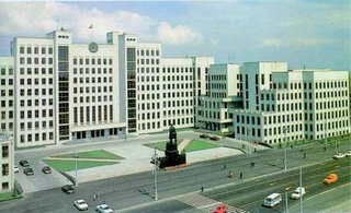
Minsk, Belarus, largely leveled by the Nazis in World War II, became in the 1950s a showcase for Soviet urban-planning, conducted on a highly rational, either neo-Enlightenment or Neo-Constructivist, basis. Here is a description of Minsk post-War urban planning, according to the Belarussian State University, in Minsk. Note the referrences to geometry, lines, squares, and circles:
"The decisive role in determining the urban development and architecture of Minsk was played by its status of the capital of Belarus as a major political, economic, and culture center, by its geo-economic situation at the crossroads of railroads, motorways and airlines. The street-pattern of the city is a "circular-radical" character and it has the following three noticeable features:
* the main city diameter is the Skorina Avenue [named after the founder of printing in Belarus in the 16th c.], crossing the city from the West to the East, being the most respectable neighborhood city axis, along which the main city squares are threaded (Independence Square, October Square, Victory Square, Y. Kolas Square, Kalinin Square), and the most important administrative, social, and recreation centers, as well as various services;
* the "green and blue" diameter (a kind of a belt formed by parks, public gardens, by a cascade of “green” reservoirs) cross the city from the North to South forming the main recreation zone;
* the system of three transport "circles", the largest of them, the circular suburban motorway, over 60 kilometers long, is a dimension limit for today's Minsk;...
Vast living zones were formed in the peripheral parts of the city by 1970-1980 ...
There are over 200 state-owned enterprises — plants, factories, works, science and production amalgamations. Their ‘age’ is mostly 20-50 years, but there are also “survivors” from the previous [19th] century."
Belarussian State University, Minsk, Belarus
[Click on photo for greater detail.]
Source and Photo credit: Belarussian State University, Minsk, Belarus www.bsu.by
Kharkiv, Ukraine, a capital of the eastern part of that country, first grew rapidily under industrialization in the second half of the 19th c., but then received an injection of Soviet Futurist or Constructivist urban planning in the 1920s.
Minsk, Belarus, largely leveled by the Nazis in World War II, became in the 1950s a showcase for Soviet urban-planning, conducted on a highly rational, either neo-Enlightenment or Neo-Constructivist, basis. Here is a description of Minsk post-War urban planning, according to the Belarussian State University, in Minsk. Note the referrences to geometry, lines, squares, and circles:
"The decisive role in determining the urban development and architecture of Minsk was played by its status of the capital of Belarus as a major political, economic, and culture center, by its geo-economic situation at the crossroads of railroads, motorways and airlines. The street-pattern of the city is a "circular-radical" character and it has the following three noticeable features:
* the main city diameter is the Skorina Avenue [named after the founder of printing in Belarus in the 16th c.], crossing the city from the West to the East, being the most respectable neighborhood city axis, along which the main city squares are threaded (Independence Square, October Square, Victory Square, Y. Kolas Square, Kalinin Square), and the most important administrative, social, and recreation centers, as well as various services;
* the "green and blue" diameter (a kind of a belt formed by parks, public gardens, by a cascade of “green” reservoirs) cross the city from the North to South forming the main recreation zone;
* the system of three transport "circles", the largest of them, the circular suburban motorway, over 60 kilometers long, is a dimension limit for today's Minsk;...
Vast living zones were formed in the peripheral parts of the city by 1970-1980 ...
There are over 200 state-owned enterprises — plants, factories, works, science and production amalgamations. Their ‘age’ is mostly 20-50 years, but there are also “survivors” from the previous [19th] century."

Belarussian State University, Minsk, Belarus
[Click on photo for greater detail.]
Source and Photo credit: Belarussian State University, Minsk, Belarus www.bsu.by
posted by Garth Trinkl at 9:06 AM
![]()


0 Comments:
Post a Comment
<< Home